By Sean Fagan
.
.
“Maps are a universal medium for communication, easily understood and appreciated by most people, regardless of language or culture”. (Merriam 1996)
.
.
Using Maps
for
Archaeology, Folklore
& Old Place Names
.
To my mind, a good topographical map is a thing of beauty and intrigue.
With a map (and compass) I can usually navigate, safely and accurately, to most destinations…
And that’s a very reassuring, liberating feeling.
.
Most navigators worth their salt know the true value of a good map.
Besides the navigational merits of maps – what else are maps good for?
Well, quite a lot really.
Here are just three ways to expand your use of maps - which can give a map & compass navigator a much deeper understanding (and enjoyment) of an area.
.
.
1. ARCHAEOLOGY
The glorious ruins of the past
.
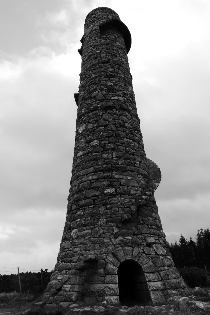
Archaeology both old and not so old exist all over Ireland (and elsewhere) and are well represented on the ordnance survey maps of Ireland. Above, a 19th century lead mine chimney, County Wicklow (Photo: Sean Fagan).
.
Archaeological remains can be surprisingly common in a landscape but finding them can be quite challenging as many archaeological features have deteriorated considerably over time.
Maps are often the perfect guide for finding many of these hidden gems from the past.
In Ireland there is a wealth of archaeological features displayed on the ordnance survey maps of Ireland. Some of these features are prehistoric - such as souterrains, burial chambers, forts, fulacht fiadhs and midden sites.
There is also a wealth of non-prehistoric archaeological sites such as Norman Motte and Baileys, churches, ogham stones, holy wells, famine graveyards and old monasteries/convents etc.
All these archaeological features add a tremendous richness and depth to a landscape....waiting to be explored.
.
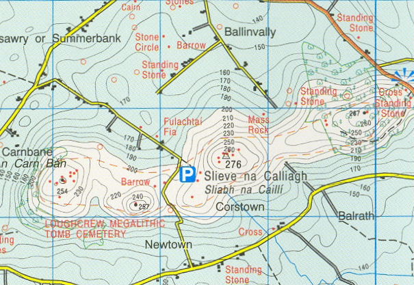
Above: section of an Ordnance Survey Map of Ireland. In this archaeologically rich area of northwest county Meath, Ireland – there are barrows, fulachai fias, stone circles, standing stones, a megalithic Tomb cemetery, cairns, a mass rock and a cross. There are many archaeologically rich areas in Ireland that are, like the area above, well represented on the Ordnance Survey Maps of Ireland (photo: Wikimedia Images).
.
I find prehistoric archaeology especially interesting.
Visiting an ancient relict when I’m hiking nearly always turns out to be welcome diversion and can certainly add to the aura of a wild place.
For those of you that practise many bushcraft skills - your plate is probably already full trying to master the broad and divergent skills of bushcraft and you probably have scant time for ‘extracurricular’ outdoor activities like archaeology and folklore.
However, connecting with people from the past can be a welcome means of fueling a passion for bushcraft.
How people lived and practised bushcraft, especially prehistorically, can be a great source of inspiration for many bushcrafters.
And maps can help you find these ancient clues in a landscape.
.
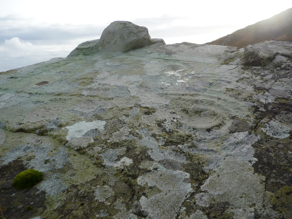
In Ireland, Bronze Age rock art were often circular engravings made on prominent rocks. Star maps? Celestial calendars for significant annual activities such as sowing seeds or hunting certain game throughout the year? We simply don't know. (Photo: Sean Fagan).
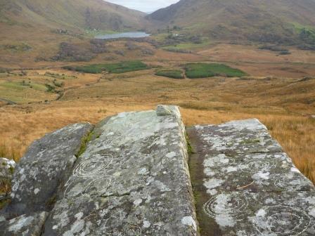
Interestingly, a lot of the famous rock art of Ballagh Beama pass, Southwest Ireland, are aligned with East (90 degrees). In the distance, the gap between the mountains (just above the lake in photo) is almost exactly due east, exactly where the sun arises for a significant portion of the year. Coincidence or intended design? (Photo: Sean Fagan).
.
.
2. PLACE NAMES & FOLKLORE
Whispers from the past
.
The old places names of an area can paint a picture of a landscape that was very different from its present status.
Some place names are very old, passed on through many generations.
For example, the Hag’s Glen in southwest Ireland, is a wide, treeless, boggy valley typical of most sheep-grazed mountains of Ireland.
But if you examined the Irish place names of the Hag’s glen, the echoes of a world mostly forgotten, can still be heard - such as Ceim on Fia (Step of the Deer), Talamh na Broc (Land of the Badger) and Nead an Iolair (Nest of the Eagle).
These place names can transport us, in our imaginations, to a wilder past when our ancestors roamed over a more wooded, more wildlife-rich landscape.
It’s easy to assume that the place names of the Hag’s Glen such as, for example, Nead on Iolair (the nest of the eagle) were created by people in the past with fertile imaginations.
However, both native eagle species, the golden and white-tailed sea eagle were present throughout the high mountains of the southwest, including Hag’s Glen (until they were sadly persecuted into extinction).
Throughout Ireland there are many eagle place names associated with mountainous areas - which is hardly remarkable considering that mountains are a favoured habitat type for both native eagle species of Ireland.
.
![White_tailed_Sea_Eagle[1] - Copy](http://www.pioneerbushcraft.org/wp-content/uploads/2015/05/White_tailed_Sea_Eagle1-Copy.jpg)
The white tail sea eagle has a few Gaelic names. One of its more striking, more poetic names is Iolair Suil na Greinne – the Eagle of the Sunlit-Eye. It’s not hard to see why, from the above photo, the inspired origins of this name (photo: Wikimedia Commons).
.
Even the place names that have questionable meanings often give us an interesting peek into the history of human occupation of an area.
Another Hag’s Glen place name is Cnoc na Peiste - a formidable, 988 metre high mountain, which means the hill of the serpent or hill of the worm.
Serpents? Worms? Why these names?
Such ambivalent place names can spur on some enjoyable imaginative wanderings for the curious mind. Besides, it’s nice to have some mystery about a landscape.
Overall, place names add a fascinating and enriching dimension to the outdoors - and maps can facilitate that connection with the past.
I highly recommend using maps that stretch beyond good topographical accuracy for navigation purposes.
.
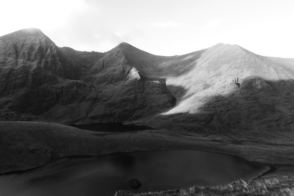
In this photo alone, of the western portion of the Hags Glen, there are at least 15-20 Irish places names for the many topographical details. Some of the place names date from the 18th century, some from medieval times. There is a good chance that some date from the first farmers, the Neolithic people or even further back in history when Ireland was populated by small, nomadic groups of hunters and gatherers. The simple answer is we don’t know when a lot of the place names were created and if there was multiple (now forgotten) place names for a given area associated with successive waves of human colonisation (Photo: Sean Fagan).
.
Concluding Thoughts
.
Bushcraft is many things. An aspect of bushcraft is engaging, not just technically, but also imaginatively and emotionally with a landscape.
When we imaginatively merge with a landscape – that place can become more vivid, more enjoyable, more meaningful.
And the more we enjoy something, the more we seek to savour and study its myriad details.
There is something expansive about perceiving a landscape through different filters – and archaeology, folklore and old place-names are three ways of merging with nature and the great outdoors.
.
The Freedom of Bushcraft
.
One of the great strengths of bushcraft is that we can travel to wild places with minimal equipment and fuss. We can experience wilder, remote places of the earth with a freedom that can be exciting, even exhilarating.
I urge you to find out what non-bushcraft aspects of a landscape resonate with you – and then use the enabling skills of bushcraft to facilitate your explorations of such places.
Maps and map reading can give the outdoor person a renewed appreciation of the treasures that wait, mostly hidden, in a landscape.
A map is not just a tool for navigation; it can be so much more.
.
Have safe and grand adventures,
Pioneer Bushcraft.
Related articles on this website:- Using the Constellation of Orion to Navigate
- How Vantage Points Can Improve your Navigation & Survival Skills
- 7 Reasons to Camp in Winter
- 4 Wilderness Safety Tips
Useful Map Information
.
The Ordnance Survey Ireland maps cover the Republic of Ireland. Each map covers a 40 x 30km section of Ireland with a total of 75 maps covering the entirety of the republic. The scale of these maps is relatively large (1:50,000) and is ideal for navigation purposes. They also have a good representation of archaeological features throughout Ireland with recent editions representing Irish place names fairly well.
Make sure to purchase the laminated version of these maps if you are planning on repeatedly navigating in an area. Laminated maps last a lot longer than non-laminated paper versions of the Ordnance Survey maps.
Ordnance Survey Ireland - National Mapping Agency.
.
The three, excellent, Harvey Superwalker Series Maps of select locations in Ireland are of a smaller scale (1:30,000) than ordnance survey maps but are fantastically detailed, more accurate and excellent for navigation. The areas that the Harvey maps cover in Ireland is the McGillycuddy’s Reeks Mountain range, Connemara and the Wicklow Mountains. I highly recommend them.
Harvey Maps of Ireland Catalogue
.
Finally, an honourable mention to Tim Robinson’s Map of the Burren and the Connemara of West Ireland. Tim spent years walking the length and breadth of the Burren mapping its many details - topographical, historical and much more...
Tim’s black and white map is a joy to pore over. The map contains many quirky, interesting details but lacks contour lines so is not ideal for navigation even though the map is accurate in scale.
Tim Robinson's Map of the Burren
The limestone mountains and plateaus of the Burren contain the greatest variety of wild plants in Ireland. In my opinion, an amazing place. If you want to boost your plant ID skills to the next level a visit to the Burren, during summer, will greatly improve your botany skills.
PDF info sheet about the Burren
.
.
PIONEER BUSHCRAFT DISCLAIMER
.
The above article provides good outdoor advice when applied appropriately. It’s not the intention of Pioneer Bushcraft to encourage reckless behaviour and is therefore not responsible for the misapplication of the advice offered in this article.
Many bushcraft activities carry some element of risk – navigation included. It’s your responsibility to know all the risks associated with the bushcraft activities you choose to participate in.
Take your safety and well-being seriously. It’s a vital part of enjoying the great outdoors.
And most importantly – enjoy yourself. Outdoor confidence & competence and enjoying yourself when outdoors go very much go hand-in-hand.

Recent Comments